By Kai Ioh and KE TEAM Hawaii
Kai Ioh is a luxury real estate advisor based in Kona, Hawai‘i, specializing in second home, resort, and ultra-high-net-worth markets across the Big Island.
Super El Niño 2026-27 in Hawaii is becoming much more than an abstract climate story. For those of us living on the Big Island, especially around Kona and the Kohala Coast, changes across the tropical Pacific can influence trade winds, rainfall, tropical storm activity and the way our climate feels day to day.
After 25 years of living in Hawaiʻi, I cannot remember a summer that has felt this consistently hot and humid.
Hawaii is certainly not Phoenix or Tokyo in August. One of the reasons I love living on the Big Island is our remarkably comfortable climate. But this summer has felt different. There have been days when the air simply feels heavier, warmer, and much more tropical than what I have become accustomed to. Most homes in Kona built at elevations over 500 ft do not have an air conditioning system. I have never considered installing one in my house, but I am thinking about it. I still feel this year is an anomaly. I hope I am right.
Something significant is happening across the Pacific.
A powerful El Niño is already underway, and scientists expect it to become very strong as we move toward winter 2026-27. Some media outlets have started calling it a "Super El Niño."
Naturally, I became curious about what this could mean not only for Hawaiʻi, but also for California and the U.S. mainland, Japan, and the rest of the world.
Key Takeaways
El Niño is a large-scale shift in tropical Pacific Ocean temperatures and atmospheric circulation. "Super El Niño" is useful shorthand, but it is not an official scientific category.
The current El Niño is expected to strengthen significantly through late 2026 and influence weather patterns well into 2027.
Hawaiʻi could move from an unusually active hurricane season into a drier-than-normal winter, although seasonal forecasts describe probabilities rather than guarantees.
Conditions on the Big Island can vary dramatically by elevation and location. Kona, the Kohala Coast, Hilo and the upland communities can experience very different weather at the same time.
California, the broader U.S. mainland and Japan may also see characteristic El Niño patterns, but individual storms, cold waves and regional variations will still matter.
A Very Strong El Niño Is Building Across the Pacific
El Niño is not a storm. It is a massive shift in ocean temperatures and atmospheric circulation across the tropical Pacific.
Under normal conditions, easterly trade winds push warm surface water westward toward Asia and Australia. During El Niño, those equatorial Pacific trade winds weaken and warm surface water spreads eastward across the Pacific. Tropical rainfall patterns shift with it.
That change may begin thousands of miles from Hawaiʻi, but it can eventually rearrange weather patterns across much of the planet.
This El Niño is looking anything but ordinary.
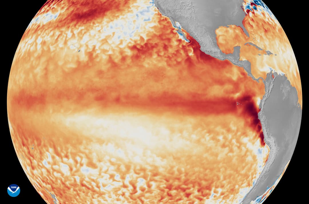
The World Meteorological Organization reported on September 3 that El Niño is firmly established and expected to intensify into a very strong event. Its forecast indicated a nearly 100% probability that El Niño will persist through February 2027.
NOAA is similarly forecasting a greater than 90% chance of a very strong El Niño during fall and winter 2026-27. NOAA also estimates a 69% chance that the October through December period could reach a level exceeding previous El Niño events in its modern record dating back to 1950.
That is remarkable.
"Super El Niño" Is Shorthand, Not a Scientific Category
One distinction is important.
"Super El Niño" is not an official scientific classification. Scientists generally describe El Niño events according to their measured strength.
The phrase is useful shorthand for an exceptionally powerful event, but it should not be interpreted as a separate type of El Niño.
That distinction matters because dramatic terminology can sometimes make seasonal forecasts sound more certain than they really are.
Hawaiʻi's Hot and Humid Summer Has Several Influences
I would not blame everything we have experienced this summer on El Niño.
Hawaiʻi's trade winds are our natural air conditioner. When they are blowing normally, they move air across the islands and make even warm temperatures considerably more comfortable.
When the trades weaken, we notice it immediately.
This summer has included periods of unusually light winds and muggy conditions. NOAA's September outlook also favors above-normal temperatures across the Hawaiian Islands.
At the same time, we have had plenty of normal trade-wind days. It would be too simple to say that Super El Niño caused our hot summer. August and September have been unusually humid due to hurricane activity. Lala, Moke, and Lowell came and went within a 4-week span.
An Unusually Active Central Pacific Hurricane Season
The 2026 hurricane season has certainly gotten our attention.
By early September, the Central Pacific had already experienced five named tropical cyclones, four hurricanes and two major hurricanes. Overall cyclone energy was also running more than 300% above normal for this point in the season.
NOAA had forecast an above-normal Central Pacific hurricane season earlier this year, with a 70% probability of above-normal activity and an expectation of five to 13 tropical cyclones. The developing El Niño was one of the factors behind that outlook.
Here on the Big Island, geography gives us a fascinating relationship with tropical storms.
Big Island Terrain Can Help, But It Does Not Make Us Immune
Kona can sometimes benefit from the enormous terrain of Mauna Loa and Mauna Kea, depending on the direction from which a storm approaches.
Scientific research has shown that the Big Island's 13,000-foot mountains can significantly disrupt airflow, alter a tropical cyclone's track and change its structure.
The southern and eastern sides of the island can be much more exposed when storms approach from the east or southeast. Hurricane Iselle in 2014 weakened as it interacted with the Big Island's terrain, but still caused serious impacts on the east side.
Research also shows that mountains do not simply act like a wall. Their interaction with a tropical cyclone can be complicated.
We were reminded of that again with Hurricane Lala in August. Its eyewall passed near the southern Big Island, and parts of the southeast side experienced extremely heavy rainfall and dangerous flooding. Kona had minimal damage thanks to the mountains, but we still need to be prepared just in case.
Then came Hurricane Lowell.
Lowell did not technically make landfall on Kauaʻi. It passed west of Niʻihau and Kauaʻi on September 7 and 8. But calling it a "near miss" almost understates what happened.
Kauaʻi experienced damaging winds, heavy rain and high surf. Preliminary National Weather Service observations recorded a 92 mph gust at Puʻu Lua and an 84 mph gust at Līhuʻe Airport. Roughly 90% of Kauaʻi's electric customers lost power at some point during the storm.
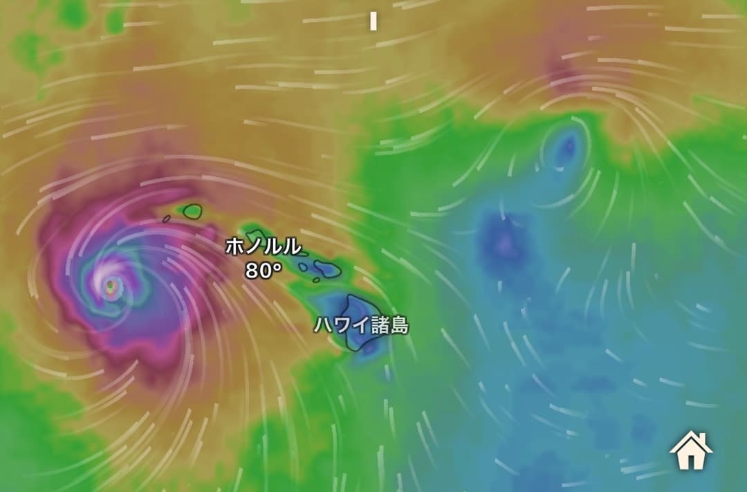
Lowell is a very good reminder that a hurricane does not need to make direct landfall to cause serious damage in Hawaiʻi.
And the season is not finished.
The official Central Pacific hurricane season continues through November 30. Most activity occurs during July, August and September, but tropical cyclones can occur later.
So while we begin thinking about winter weather, hurricane preparedness should remain on our minds.
Super El Niño 2026-27 in Hawaii Could Mean a Drier Winter
Here is where the story becomes almost counterintuitive.
After a warm, humid and unusually active hurricane season, Hawaiʻi could move into a notably drier winter.
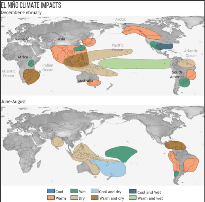
Winter, or hoʻoilo, is normally our wetter season for many parts of Hawaii. Historically, however, strong El Niño events tend to suppress rainfall across Hawaiʻi during late fall and winter.
NOAA's seasonal outlook shows below-normal rainfall becoming increasingly likely across the Hawaiian Islands beginning around October through December, with that tendency continuing into spring 2027.
For Hilo, one of the wettest major cities in America, NOAA currently gives a 65% probability of below-normal precipitation during December, January and February.
That does not mean it will not rain. It also does not guarantee severe drought.
Seasonal Forecasts Describe Odds, Not Certainty
This is probably the most important point in the entire discussion.
Seasonal forecasts are probabilities, not promises.
A substantially drier-than-normal wet season could have practical consequences for agriculture, ranching, landscaping and water availability. If dry conditions persist, wildfire risk can also become a greater concern.
But even during a dry El Niño winter, individual locations can receive heavy rain.
That is especially true on the Big Island.
Big Island Microclimates Still Matter Most
The Big Island is an excellent place to see why broad climate forecasts need local context.
Someone living near the coast in Kailua-Kona can experience completely different conditions from someone living 1,000 or 2,000 feet higher on the slope of Hualālai mountain. Hilo can be wet while the Kohala Coast is almost completely dry.
Drive 15 minutes uphill from the Kona Coast and the temperature can change noticeably. Drive from sunny Waikoloa to Waimea and suddenly you may want a jacket. Continue toward Hilo and you may find rain.
Elevation, prevailing wind, shade, home orientation, landscaping and ventilation all influence daily comfort.
This is something I talk about often with real estate clients.
Weather is not simply background scenery in Hawaiʻi. It is part of the lifestyle. Unlike many mainland markets, understanding the microclimate can be nearly as important as understanding the floor plan.
That is especially relevant for second-home owners who may experience the property during only certain seasons.
California and the U.S. Mainland May See a Different Winter Pattern
For my mainland friends and clients, winter 2026-27 could look very different depending on where you live.
A strong El Niño tends to shift the Pacific jet stream and increase the odds of a more recognizable El Niño winter pattern.
NOAA's current outlook favors warmer conditions across much of the northern United States, while El Niño increasingly influences precipitation patterns as winter progresses.
For California, where so many of my clients and friends live, an active southern storm track can be both welcome and problematic.
Additional rain and mountain snow can help water supplies. But when strong storms arrive too quickly, the same moisture can create flooding, landslides, erosion and difficult travel.
El Niño does not guarantee California will have a wet winter.
It also does not mean Boston cannot have a blizzard or Colorado will not receive significant snow.
El Niño changes the odds across an entire season. Individual storms and cold outbreaks can still occur almost anywhere.
Japan May Lean Milder, But Winter Will Still Be Winter
Japan is particularly interesting because El Niño influences weather patterns on the opposite side of the Pacific as well.
On September 9, the Japan Meteorological Agency confirmed that El Niño conditions have continued since spring 2026 and gave a 100% probability that El Niño will continue through the coming winter.
Historically, El Niño winters in Japan tend to lean milder in some regions.
But I would be careful with the phrase "warm winter."
Japan can still experience significant cold waves and heavy snow during an overall mild season. Anyone who has spent January in Hokkaido knows that a "mild El Niño winter" is very relative!
The better way to think about it is that El Niño shifts seasonal probabilities. It does not eliminate normal winter weather.
More detailed regional forecasts from the Japan Meteorological Agency should give a clearer picture as we move further into fall.
Living in Hawaiʻi Makes the Pacific Feel Very Small
One of the things I appreciate after living here for 25 years is how Hawaiʻi constantly reminds you that nature is connected.
A change in ocean temperatures thousands of miles away can eventually influence our rainfall, surf, tropical storm activity and even how comfortable it feels sitting outside on the lanai.
On the Big Island, those differences become even more local.
That is part of what makes living here so fascinating.
It is also why understanding elevation, airflow, sun exposure and microclimate can be just as important as square footage when choosing a home in Kona or along the Kohala Coast.
For now, I will be watching this El Niño closely.
After 25 years, Hawaiʻi can still surprise me. Judging from what we have already experienced this summer, winter 2026-27 may be another very interesting chapter.
Frequently Asked Questions
What is a Super El Niño?
"Super El Niño" is an informal term used to describe an exceptionally strong El Niño event. It is not an official scientific classification. El Niño itself is a warming of the central and eastern tropical Pacific that changes atmospheric circulation and can influence weather patterns around the world.
How strong could the 2026-27 El Niño become?
Current forecasts indicate that El Niño is likely to become very strong during fall and winter 2026-27. NOAA has estimated a greater than 90% chance of a very strong event, while the World Meteorological Organization expects El Niño to persist through February 2027.
Does El Niño make Hawaiʻi hotter?
El Niño can influence temperatures, winds and rainfall around Hawaiʻi, but it should not be blamed for every hot or humid period. Local trade winds, ocean temperatures and other atmospheric conditions also affect how Hawaiʻi feels from day to day.
Does El Niño mean Hawaiʻi will have a dry winter?
Strong El Niño events historically increase the likelihood of below-normal winter rainfall in Hawaiʻi. Current seasonal forecasts favor drier conditions beginning in late 2026 and continuing into spring 2027. These are probabilities, however, and individual heavy rain events can still occur.
Does El Niño increase hurricane risk in Hawaiʻi?
El Niño can create atmospheric conditions that are more favorable for tropical cyclone activity in the Central Pacific. The 2026 season has already been unusually active. However, El Niño does not determine whether an individual hurricane will approach or affect the Hawaiian Islands.
Do Mauna Loa and Mauna Kea protect Kona from hurricanes?
The Big Island's massive mountains can disrupt tropical cyclone circulation and sometimes reduce impacts on portions of the island. They do not create complete protection. A storm's track, size, intensity and approach direction all matter, and different parts of the island can experience very different effects.
What could El Niño mean for California this winter?
A strong El Niño can favor a more active southern storm track, which may increase opportunities for rain and mountain snow in California. It does not guarantee a wet winter. Individual storms, their timing and their locations ultimately determine whether the season brings beneficial precipitation or problems such as flooding and landslides.
What does El Niño usually mean for Japan?
El Niño winters in Japan often lean milder in some regions, but significant cold spells and heavy snow can still occur. El Niño changes seasonal probabilities rather than eliminating normal winter weather.
Why do microclimates matter so much on the Big Island?
The Big Island has large differences in elevation, terrain, rainfall, wind exposure and sun exposure within relatively short distances. A home near sea level in Kona can feel very different from one several hundred or several thousand feet higher. These microclimates directly affect temperature, ventilation, landscaping and everyday comfort.
Why does weather matter when choosing a home in Kona?
In Kona, climate is closely connected to lifestyle. Elevation, airflow, sun exposure and orientation influence whether a home feels comfortable with open windows, how often air conditioning is needed and how outdoor spaces are used. For many buyers, these factors can be just as meaningful as the home's interior features.